top of page
Search

Aerial Rendering in Architectural Visualization: Context, Scale, and Project Communication

  • Aug 29, 2025
  • 9 min read

Updated: 6 days ago

Aerial Rendering in Architectural Visualization: Context, Scale, and Project Communication

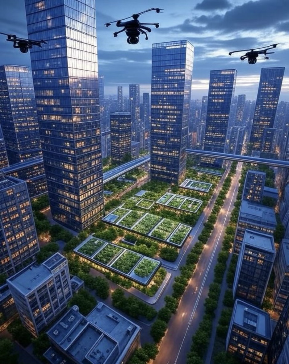
Aerial rendering in architectural visualization helps project teams understand more than the appearance of an individual building. By presenting architecture from an elevated or bird’s-eye viewpoint, an aerial image can explain how a proposed project relates to its site, neighboring properties, roads, parking, landscape, infrastructure, and future development phases.

This broader perspective is valuable because many architectural decisions cannot be evaluated effectively from ground-level renderings alone. A street-level image may communicate façade materials, entrances, lighting, and pedestrian experience, but it may not explain the overall organization of a campus, mixed-use development, residential community, industrial site, data center, or master plan.

Professional aerial rendering services combine architectural models, site information, surrounding context, landscape design, and camera strategy within one coordinated visual. The objective is not simply to create an attractive image from above. The objective is to make complex spatial relationships understandable to architects, developers, owners, investors, reviewers, and other stakeholders.


Aerial Rendering

What Aerial Rendering Adds to Architectural Visualization

Architectural visualization translates drawings, models, specifications, and design concepts into visual information that can be reviewed by both technical and nontechnical audiences. Aerial rendering expands that communication by showing the architecture as part of a larger physical system.

Depending on the project, an aerial view can communicate:

  • Building placement, orientation, massing, and height

  • Property boundaries and development limits

  • Roads, intersections, entrances, and service access

  • Parking areas, loading zones, and circulation routes

  • Pedestrian paths and connections between buildings

  • Landscape zones, courtyards, buffers, and open spaces

  • Relationships with neighboring properties

  • Connections to highways, transit, utilities, or infrastructure

  • Development density and land-use organization

  • Multiple construction phases or planned expansions

  • Existing conditions compared with proposed improvements

A coordinated aerial image allows these elements to be evaluated together. This helps an audience understand not only what is being designed, but also where it is located, how it functions, and how it affects the surrounding context.


Context, Scale, and Site Relationships

One of the principal advantages of aerial rendering in architectural visualization is its ability to communicate context.

Architecture is never experienced in isolation. Even a single building is influenced by its site boundaries, setbacks, access points, topography, landscape, surrounding structures, utilities, visibility, and connections to public space. Larger developments introduce additional relationships involving circulation, phasing, density, service areas, parking, infrastructure, and neighboring land uses.

An aerial perspective can make these relationships visible within a single composition. It can show whether an entrance is understandable, whether buildings are properly oriented, how vehicles and pedestrians move through the property, where landscape buffers occur, and how the development fits within its larger setting.

Scale is equally important. Technical site plans may contain accurate dimensions, but many viewers have difficulty translating two-dimensional information into a clear understanding of spatial scale. An aerial rendering can make the relationship between buildings, roads, open spaces, vehicles, and people more immediate without replacing the underlying drawings.


Aerial Rendering

When Aerial Rendering Creates the Most Value

Aerial visualization can support many building and development types, but it becomes particularly valuable when decisions depend on site-wide relationships.


Master-Planned and Mixed-Use Developments

Master-planned projects may contain multiple buildings, streets, public spaces, amenities, landscape systems, parking areas, and future phases. Aerial rendering can explain how these elements work together and how the development may be experienced as a complete environment.

For mixed-use projects, an aerial image may also distinguish residential, commercial, hospitality, office, retail, and public components while showing their physical connections.


Residential and Real Estate Development

Developers can use aerial renderings to communicate building placement, amenities, surrounding context, landscape, access, and community organization before construction is complete.

These images may support:

  • Investor presentations

  • Development announcements

  • Leasing and sales materials

  • Property websites

  • Planning presentations

  • Community discussions

  • Internal design reviews

  • Marketing campaigns

An effective image should communicate the project accurately and support its development strategy. It should not introduce unsupported architectural features simply to make the presentation appear more dramatic.


Commercial, Industrial, and Data Center Campuses

Commercial and industrial sites often include information that cannot be explained adequately through a single ground-level view. An aerial rendering can show office buildings, production areas, loading zones, parking, access control, utility areas, landscape screening, and future expansion zones.

For a data center campus, the aerial viewpoint may help communicate building placement, security boundaries, circulation, utility-related areas, landscape treatment, stormwater features, and phased development. Technical information should be based on current project documents and coordinated with the responsible project team.


Institutional and Infrastructure-Related Projects

Hospitals, educational campuses, public facilities, transportation projects, energy facilities, and infrastructure-related developments often involve multiple audiences with different levels of technical knowledge.

Aerial visualization can help those audiences understand access, circulation, building relationships, site constraints, public interfaces, and future development without requiring them to interpret several separate technical drawings.


Planning, Entitlement, and Stakeholder Communication

Planning officials, community stakeholders, investors, and executive decision-makers may need to evaluate a project without regularly working with architectural plans or BIM models.

An aerial image can help clarify:

  • The project’s location and boundaries

  • Building height and massing

  • Relationships with nearby properties

  • Public and private circulation

  • Landscape and open-space organization

  • Development density

  • Proposed phases

  • Connections to surrounding roads and infrastructure

RENDEREXPO’s guide to aerial rendering for urban planning and development examines this specialized planning application in greater technical depth.


Aerial Rendering, Drone Photography, and Site-Plan Graphics

Aerial rendering is related to drone photography and site-plan graphics, but these formats serve different purposes.


Aerial Rendering

An aerial rendering represents a proposed, renovated, or future condition. It can be created before construction and can incorporate architecture, landscape, infrastructure, surroundings, and development phases that do not yet exist.


Drone Photography

Drone photography documents existing conditions at a particular moment. It can provide valuable information about the current site, surrounding context, topography, access, and neighboring development.

Drone photographs may also be used as a foundation for photomontage, allowing proposed 3D architecture to be coordinated with real aerial imagery.


Site-Plan Graphics

A site-plan graphic prioritizes organization and clarity. It may use simplified building forms, labels, color coding, boundaries, circulation arrows, and other diagrammatic information.

A photorealistic aerial rendering prioritizes visual realism and spatial experience. A diagram prioritizes explanation. Many projects benefit from using both rather than forcing one image to serve every communication purpose.


Information Required for an Accurate Aerial Rendering

The quality of an aerial rendering depends on more than rendering software. It depends on the completeness, accuracy, and coordination of the source information.

Useful project materials may include:

  • Architectural plans, elevations, and sections

  • BIM, Revit, SketchUp, CAD, or other 3D models

  • Civil and site plans

  • Property boundaries and survey information

  • Topography and grading information

  • Landscape plans

  • Road, parking, and circulation layouts

  • Material and façade information

  • Existing-site photography

  • Drone imagery

  • GIS or mapping information

  • Neighboring-building information

  • Development phasing plans

  • Utility or infrastructure information appropriate for presentation

  • Branding and presentation requirements

Not every project will have all of these materials available. Early design projects may begin with limited information, but conceptual assumptions should be identified clearly and reviewed before the final image is used for public, investor, approval, or construction-related communication.


Camera Strategy and Visual Hierarchy

A successful aerial rendering is not created by placing a camera at an arbitrary height. The camera must be selected according to what the audience needs to understand.

A lower oblique aerial angle can show architectural character, façades, entrances, and landscape while still explaining the site. A higher bird’s-eye viewpoint can communicate overall organization, density, circulation, and development phases more clearly.

Camera decisions should consider:

  • The primary subject of the image

  • The direction from which the site is approached

  • Important roads and access points

  • Relationships between buildings

  • Landscape and open-space organization

  • Neighboring context

  • The project’s most important communication objective

  • Whether the image is intended for design review, approvals, investors, leasing, sales, or marketing

Visual hierarchy also matters. Architecture, roads, landscape, vehicles, people, and surrounding buildings should not compete equally for attention. The composition should guide the viewer toward the most important project information.


The Professional Aerial-Rendering Workflow

A controlled aerial-rendering process typically includes several stages.

1. Define the Audience and Purpose

The team identifies who will view the image, what they need to understand, where the visual will be used, and which project decisions it should support.

2. Review the Source Information

Architectural, site, civil, landscape, and contextual information is reviewed. Missing or inconsistent information should be identified before detailed production begins.

3. Build or Refine the Coordinated Model

Buildings, site elements, roads, landscape, and surrounding context are organized within a coordinated 3D environment.

4. Establish the Camera

Preliminary camera options are developed before detailed materials and entourage are finalized. This prevents production effort from being invested in a viewpoint that does not explain the project effectively.

5. Develop Materials, Landscape, and Context

Project-specific materials, vegetation, roads, neighboring conditions, signage, people, vehicles, and environmental elements are incorporated according to the required level of accuracy.

6. Review Project Information

The project team reviews massing, placement, access, circulation, landscape, context, and relevant phases. Feedback should be consolidated and based on current project documents.

7. Prepare the Final Deliverables

The approved image is refined and prepared for its intended use, including presentations, websites, print materials, investor packages, planning exhibits, leasing campaigns, or large-format displays.

RENDEREXPO’s broader architectural visualization, CGI, and animation services can combine aerial images with ground-level exterior renderings, interiors, animation, 3D floor plans, and other presentation assets.


AI-Assisted Exploration Versus Model-Based Aerial Rendering

AI-assisted tools can help teams explore early visual directions, atmospheres, landscape concepts, material ideas, and possible compositions. They can be useful when a project is still conceptual and the objective is to generate discussion rather than confirm technical information.

The RENDEREXPO AI Architectural Rendering Assistant allows users to refine a written prompt or reference image and generate an initial architectural concept visual free. This can support early exploration and creative communication.

However, AI concept imagery should not be confused with a technically controlled aerial rendering. Projects requiring verified geometry, coordinated viewpoints, accurate site relationships, entitlement information, construction decisions, or investor-ready deliverables should move to a model-based professional workflow.

The appropriate method depends on the decision being made. Early exploration may benefit from speed and flexibility. Formal project communication requires greater control, traceability, and coordination.


Choosing the Right Aerial-Rendering Partner

A qualified aerial-rendering team should be able to do more than produce polished imagery. It should understand architectural drawings, site organization, project context, intended audiences, and the decisions the visual must support.

When reviewing a visualization partner, consider whether the team can:

  • Interpret architectural, civil, landscape, and site information

  • Work with BIM, CAD, PDF, and reference files

  • Identify missing information and assumptions

  • Coordinate architecture with its surrounding context

  • Select cameras based on communication objectives

  • Maintain consistency across multiple images

  • Produce appropriate formats and resolutions

  • Organize a controlled review process

  • Distinguish conceptual elements from confirmed design information

  • Support investor, planning, marketing, and stakeholder presentations

The portfolio should demonstrate relevant project scale, site complexity, architectural understanding, and visual quality. RENDEREXPO’s architectural visualization portfolio includes exterior, interior, aerial, commercial, residential, and complex-project visualization.


Aerial Rendering

Frequently Asked Questions About Aerial Rendering in Architectural Visualization

What is aerial rendering in architectural visualization?

Aerial rendering is the creation of a three-dimensional image showing a proposed building, site, campus, or development from an elevated viewpoint. It communicates the relationship between architecture, landscape, roads, infrastructure, neighboring properties, and surrounding context.


What is the difference between aerial rendering and exterior rendering?

Exterior rendering normally focuses on the building from a pedestrian or street-level viewpoint. Aerial rendering uses a higher camera position to explain site organization, building placement, circulation, landscape, and broader context.


Can aerial renderings be created before the design is finalized?

Yes. Aerial renderings can support early planning and schematic design, but conceptual assumptions should be identified clearly. The image can be updated as the architecture, landscape, site, and infrastructure information develops.


Can an aerial rendering use real drone photography?

Yes. A proposed 3D model can be coordinated with drone photography through photomontage. The camera position, perspective, lighting, scale, and site placement must be aligned carefully for the result to appear credible.


What projects benefit most from aerial visualization?

Aerial rendering is especially useful for master plans, mixed-use developments, residential communities, commercial properties, industrial sites, data centers, institutional campuses, hospitality projects, infrastructure-related work, and multi-building developments.


What files are needed to begin an aerial-rendering project?

Useful materials include architectural plans, elevations, BIM or 3D models, site plans, surveys, civil information, landscape plans, material references, drone imagery, photographs, and surrounding-context information. The required inputs depend on the project stage and intended deliverable.


Can aerial renderings support planning and investor presentations?

Yes. Aerial images can explain development organization, massing, access, landscape, surrounding context, project phases, and overall investment scale. The level of detail and presentation style should be tailored to the specific audience.


Conclusion: Using Aerial Rendering to Communicate the Complete Project

Aerial rendering in architectural visualization provides a coordinated view of architecture, site, landscape, circulation, infrastructure, and surrounding context. Its value is not limited to showing a project from above. A well-planned aerial image helps project teams explain how a development is organized, how it connects to its surroundings, and how multiple architectural and site decisions work together.

For architects, developers, owners, construction teams, investors, and project stakeholders, this perspective can support design evaluation, planning communication, approvals, development presentations, leasing, sales, marketing, and executive decision-making.

RENDEREXPO develops aerial renderings as part of a broader architectural-visualization and project-communication strategy. To discuss an aerial image, coordinated rendering package, animation, or complex project presentation, contact RENDEREXPO with the available drawings, models, site information, intended audience, and required deliverables.


Comments


RENDEREXPO AI
Visualization & Digital Construction Assistant
RENDEREXPO LOGO
  • Twitter
  • Instagram
  • LinkedIn
  • Facebook
  • Pinterest
bottom of page