
RENDEREXPO GIS MAPPING SYSTEM
Indoor GIS, Outdoor GIS & Spatial Mapping Systems
RENDEREXPO, with specialized GIS partner support, helps owners, developers, architects, facility teams, campuses, and operators transform building, site, and spatial data into intelligent indoor and outdoor GIS mapping systems for navigation, wayfinding, operations, space intelligence, asset visibility, and connected spatial understanding.
WHAT WE DO
We connect building data, site data, and GIS workflows into usable spatial systems.
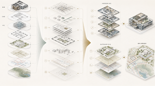
This service is not only about visualization. It is about transforming BIM, CAD, IFC, floor plans, site plans, civil information, utility data, parcel information, and environmental layers into structured mapping systems that can support real-world use.
Our approach connects digital construction data preparation with indoor GIS, outdoor GIS, and integrated indoor–outdoor mapping workflows, helping clients move from design and documentation into navigation, operations, facility management, and long-term spatial intelligence.
BIM / CAD / IFC Preparation
Indoor GIS
Outdoor GIS
Wayfinding
Floor-Aware Mapping
Campus Mapping
Space Intelligence
Asset Visibility
Utilities & Infrastructure
Environmental Layers
CORE MAPPING SYSTEM SERVICES
Prepare the data. Map the building. Map the site. Connect the full environment.
Select a service below to explore how RENDEREXPO leads indoor and outdoor GIS mapping work with specialized GIS partner support.


SERVICE DETAILS
Four connected services for indoor GIS, outdoor GIS, and operational spatial systems.
RENDEREXPO helps clients carry building and site intelligence beyond drawings and presentations into GIS-ready spatial environments that support real use.
1
GIS DATA PREPARATION
Prepare BIM, CAD, IFC, floor plans, and site data for GIS use.
Digital construction data preparation for GIS turns project information into a clean spatial foundation. We help organize building and site data so it can support indoor mapping, outdoor mapping, wayfinding, space intelligence, facility operations, and future system integrations.
What it clarifies
Floor levels, rooms, spaces, circulation, entrances, assets, site boundaries, parcels, access routes, utilities, and spatial relationships.
Best used for
Owners, developers, architects, campuses, facility teams, real estate groups, and operators who need project information translated into GIS-ready structures.
BIM Preparation
CAD Cleanup
IFC Translation
Floor Plan Structuring
Site Plan Alignment
GIS-Ready Spatial Data

2
INDOOR MAPPING / GIS
Make interior environments searchable, navigable, and operationally useful.
Indoor GIS and indoor mapping systems create floor-aware spatial environments that help people understand, navigate, manage, and operate buildings. This can support wayfinding, room and space visibility, occupancy intelligence, reservations, facility coordination, and operational planning.
What it clarifies
Floors, rooms, departments, amenities, circulation paths, entrances, exits, vertical movement, restricted areas, operational zones, and interior destinations.
Best used for
Office buildings, campuses, healthcare facilities, education buildings, hospitality, retail, industrial facilities, data centers, and multi-floor complex environments.
Indoor Mapping
Floor-Aware GIS
Interior Wayfinding
Space Intellegence
Occupancy Visibility
Facility Operation
3
OUTDOOR MAPPING / GIS
Map the site, campus, infrastructure, parcels, utilities, roads, and environmental layers.
Outdoor GIS and site mapping systems help clients understand exterior environments at the site, campus, parcel, utility, infrastructure, and environmental scale. This includes real estate and campus mapping as well as roads, access, infrastructure, parcels, environmental layers, and development context.
What it clarifies
Site boundaries, parcels, roads, access, parking, outdoor assets, utilities, substations, infrastructure corridors, environmental buffers, topography, and development constraints.
Best used for
Real estate development, campuses, data centers, industrial projects, infrastructure-linked sites, planning studies, outdoor operations, and public-facing project communication.

Campus Mapping
Site Mapping
Parcel Mapping
Environmental Layers
Utility Layers
Roads and Access
Infrastructure Context

4
CONNECTED SYSTEMS
Connect the full journey from site arrival to interior destination.
Connected indoor–outdoor spatial systems bridge the exterior and interior experience. They help teams link regional access, site arrival, parking, security, building entry, lobby experience, interior circulation, rooms, assets, amenities, and operational destinations into one coherent spatial system.
What it clarifies
Arrival routes, campus-to-building navigation, parking-to-lobby movement, building entry, indoor routing, emergency access, security zones, facility assets, and operational destinations.
Best used for
Multi-building campuses, real estate portfolios, data centers, hospitals, education campuses, industrial facilities, corporate headquarters, and complex public or private facilities.
Indoor-Outdoor Routing
Campus-to-Building Mapping
Parking-to-Lobby Experience
Emergency Routing
Asset Visibility
Digital Twin-Ready GIS
OUR PROCESS
We turn building and site information into GIS-ready spatial systems.
01
Data Review
We review BIM, CAD, IFC, floor plans, site plans, civil information, parcels, utilities, infrastructure, environmental layers, and project goals.
02
Spatial Structuring
We organize floor levels, rooms, spaces, entrances, routes, assets, site boundaries, access points, utilities, and outdoor spatial layers.
03
GIS Mapping Support
With specialized GIS partner support, we help translate structured spatial data into indoor and outdoor GIS mapping workflows and presentation systems.
04
Operational Use
We support mapping systems that help clients navigate, manage, communicate, and operate buildings, campuses, facilities, and complex environments.
WHY RENDEREXPO
Mapping systems built from architectural, spatial, and operational intelligence.
RENDEREXPO-led with GIS partner support
We lead the visual, spatial, and project communication strategy while working with specialized GIS partners where advanced implementation support is required.
Not locked into one platform
Our work can support indoor and outdoor GIS workflows across different platforms and project requirements, without limiting clients to one specific system.
Bridging design, construction, and operations
We help clients move from drawings and models into practical mapping systems that support navigation, space visibility, asset understanding, and facility use.
Indoor and outdoor spatial continuity
We connect the full spatial experience: roads, parcels, site access, parking, building entry, interior circulation, rooms, assets, and operational destinations.