
Indoor Map Maker: How to Create Accurate, Interactive Building Maps
- 3 hours ago
- 11 min read
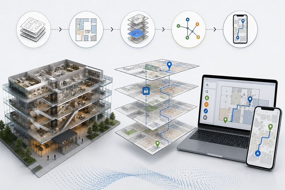
An indoor map maker converts architectural plans and building information into a structured digital map that people can search, navigate, understand, and use. Unlike a conventional floor plan, an indoor map can connect rooms, corridors, entrances, stairs, elevators, amenities, equipment, restricted areas, and operational data across multiple levels of a building.
For owners and project teams, the objective is rarely to produce another static drawing. The real objective is to create a reliable spatial system that supports indoor wayfinding, facility operations, asset visibility, emergency planning, workplace management, visitor experience, or future digital twin workflows.
Achieving that result requires more than uploading a PDF to an online map generator. Source information must be reviewed, cleaned, structured, classified, connected, and tested before it becomes operationally useful.
RENDEREXPO helps project teams prepare architectural, BIM, CAD, IFC, site, and spatial information for indoor and outdoor GIS mapping systems, connecting design documentation with practical mapping, navigation, visualization, and facility-use requirements.

What Is an Indoor Map Maker?
An indoor map maker may refer to software, a digital platform, or a professional service used to create maps of interior building environments.
At a basic level, it may convert a floor plan into a simplified digital layout. More advanced indoor mapping workflows can produce:
Floor-aware maps for multi-level buildings
Searchable rooms, departments, amenities, and destinations
Routable pathways between interior locations
Connections between stairs, elevators, ramps, and escalators
Building asset and equipment locations
Restricted, public, secure, and operational zones
Accessible routes
Indoor-to-outdoor navigation
2D, 3D, web, mobile, or kiosk-based map experiences
Spatial data that can support facility management or digital twins
Modern indoor GIS platforms can consolidate BIM, CAD, point-cloud, and floor-plan data into a shared spatial system. These maps may then support asset management, safety planning, space utilization, visitor navigation, and operational decision-making.
The important distinction is that an indoor map is not simply a visually improved floor plan. It is a structured representation of the relationships between spaces, destinations, circulation paths, assets, and users.
What Should a Professional Indoor Map Maker Produce?
The required output depends on how the building map will be used. A public-facing map for a hospital has different priorities from an operational map for a data center, industrial facility, university, office portfolio, or commercial campus.
A professional indoor map maker should therefore begin with the intended use rather than the visual style.
A Floor-Aware Building Map
Floor-aware mapping allows users to view and navigate individual building levels while retaining their relationship to the overall facility.
The system must correctly distinguish:
Floor elevations and level names
Rooms and space boundaries
Corridors and circulation zones
Open-to-below areas
Double-height spaces
Mezzanines
Vertical circulation
Separate wings or connected buildings
Without a reliable floor structure, room searches, routing, asset tracking, and multi-level navigation can become confusing or inaccurate.
Searchable Points of Interest
Points of interest identify the places users need to find. Depending on the facility, these may include:
Departments
Offices
Conference rooms
Patient services
Classrooms
Retail tenants
Restrooms
Reception desks
Security checkpoints
Loading areas
Mechanical rooms
Electrical rooms
Amenities
Emergency equipment
Parking connections
Each point should be assigned a consistent name, category, location, and level. Alternate names and common search terms may also be needed so users can find destinations using familiar language.
A Routable Indoor Network
A navigable indoor map requires more than room outlines. The indoor map maker must establish how people move through the building.
That means identifying:
Walkable corridors
Room access points
Door connections
Stairs and elevators
Accessible routes
Security-controlled areas
Staff-only circulation
Temporary closures
One-way movement
Connections between buildings
Indoor mapping standards increasingly emphasize spaces, connectivity, navigation networks, and the topological relationships between interior areas. These relationships are what allow mapping systems to calculate meaningful routes rather than simply display geometry.
Operational Data Layers
For facility and asset management, the map may also include structured operational information such as:
Equipment locations
Asset identification numbers
Maintenance zones
Inspection points
Security devices
Utility shutoffs
Fire protection equipment
Furniture or workspace assignments
Occupancy information
Service areas
Work-order locations
The appropriate level of detail should be determined by the intended users. A visitor map should remain simple, while an operations map may require significantly more technical information.

How an Indoor Map Maker Converts Plans into a Digital Map
Producing a dependable map generally involves several coordinated stages.
1. Define the Mapping Objective
The first step is determining what the map needs to accomplish.
A project intended for visitor wayfinding may prioritize searchable destinations, entrances, amenities, accessible routes, and a simple interface. A facility-operations system may prioritize spaces, assets, maintenance information, security zones, and integration with existing databases.
Questions to establish early include:
Who will use the map?
What information must they find?
Will the map support navigation?
Does it need to cover multiple floors or buildings?
Will it connect to parking, roads, or outdoor paths?
Does it require live operational information?
Who will maintain the map after occupancy?
What applications or platforms must receive the data?
Defining these requirements prevents unnecessary modeling and reduces the risk of creating an attractive map that cannot support its intended function.
2. Review the Available Source Data
An indoor map maker may receive information in several formats:
BIM models
CAD drawings
IFC files
PDF floor plans
Scanned legacy drawings
Point clouds
Laser scans
Site plans
Room data sheets
Equipment schedules
Asset databases
Existing GIS files
Field-verified measurements
The presence of a drawing does not guarantee that it is accurate, current, or suitable for mapping.
A source-data review should identify inconsistencies such as duplicate room numbers, outdated renovations, misaligned floor plans, missing doors, incorrect level names, or spaces that no longer match field conditions.
3. Clean and Simplify the Building Geometry
Construction drawings contain information that may not belong in an indoor map. Dimensions, detail references, hatch patterns, annotations, ceiling information, hidden objects, and technical symbols can make the map difficult to interpret.
The geometry must therefore be simplified without removing information required for navigation or operations.
This may involve:
Removing irrelevant annotation
Closing incomplete room boundaries
Correcting overlapping geometry
Standardizing layers
Consolidating duplicate linework
Simplifying wall geometry
Confirming doors and openings
Separating rooms from circulation
Verifying vertical connections
Aligning multiple building levels
The resulting map should be lighter and easier to manage than the original construction documentation while remaining spatially accurate.
4. Structure Rooms, Levels, and Circulation
Once the geometry is cleaned, spaces must be converted into structured spatial entities.
A room should not exist only as a collection of lines. It should carry useful attributes such as:
Room name
Room number
Floor
Department
Space type
Access classification
Occupancy category
Public or restricted status
Searchable aliases
Associated assets
The same principle applies to corridors, entrances, elevators, stairwells, parking connections, and outdoor access points.
RENDEREXPO’s indoor GIS and spatial mapping support focuses on organizing this architectural and spatial information into a clearer GIS-ready foundation.
5. Establish Location and Floor Relationships
Indoor maps often need to connect with a site, campus, municipal basemap, parcel system, or outdoor navigation environment.
That requires the building to be located correctly within a broader coordinate system. Floor levels must also align with one another so that entrances, elevators, stairs, shafts, and circulation paths connect logically.
This step becomes especially important for:
Multi-building campuses
Hospitals
Airports and transportation facilities
Universities
Corporate headquarters
Industrial sites
Data center campuses
Mixed-use developments
Large residential communities
A building that appears correct as an isolated drawing may still produce routing problems if its relationship to the site or adjacent structures is inaccurate.
6. Build the Navigation Network
For indoor wayfinding, the map maker establishes a network representing allowable movement.
A successful route must account for more than the shortest geometric distance. It may also need to consider:
Accessible circulation
Locked or restricted doors
Staff-only areas
Public operating hours
Elevator availability
Escalator direction
Security screening
Outdoor transitions
Construction closures
Emergency conditions
Different user permissions
Testing should include routes between multiple origins and destinations, especially across different floors and buildings.
7. Design the User Experience
A technically accurate map can still fail if it is difficult to read.
The visual system should clearly distinguish:
Rooms from corridors
Public spaces from restricted spaces
Primary routes from secondary routes
Interior areas from exterior areas
Current floors from adjacent levels
Destinations from background information
Permanent information from live operational data
Typography, symbols, contrast, scale, and information hierarchy should support quick comprehension on the intended device.
A lobby kiosk may require larger labels and simplified categories. A mobile map may require fewer visible details at the default zoom level. A facility-management interface may require filters, asset layers, and technical identifiers.
8. Validate and Maintain the Map
An indoor map is not complete when it is published. It must be validated against the current building condition and maintained as the facility changes.
Quality-control procedures may include:
Comparing the map with current drawings
Field-verifying critical routes
Confirming room names and numbers
Testing elevators and stairs
Reviewing accessible pathways
Checking points of interest
Validating entrances and exits
Testing searches
Reviewing permissions and restricted areas
Assigning responsibility for future updates
Renovations, tenant changes, equipment replacements, departmental moves, and revised security procedures can all affect the accuracy of the map.
Indoor Map Maker vs. Floor Plan Software
Floor plan software and indoor map makers can overlap, but they do not always produce the same result.
A conventional floor plan tool is generally focused on drawing or presenting a layout. It may show walls, doors, rooms, furniture, dimensions, and finishes.
An indoor map maker is generally focused on spatial use. It may add searchable data, floor relationships, routing, asset locations, categories, user permissions, and connections to outdoor GIS.
A floor plan answers:
What is the physical layout?
An indoor mapping system can also answer:
Where is a specific room or asset?
How do I reach it?
Which floor is it on?
Is the route accessible?
Is the space public or restricted?
What equipment is located nearby?
How does this entrance connect to parking?
Which department occupies this area?
How can facility teams update the information?
For small or temporary projects, a basic floor plan may be sufficient. For complex facilities, portfolios, or operational environments, a structured indoor mapping workflow is typically more appropriate.
Common Uses for an Indoor Map Maker
Visitor Wayfinding
Interactive indoor maps can help visitors locate entrances, rooms, departments, amenities, elevators, and other destinations.
This is particularly valuable in hospitals, universities, convention centers, corporate campuses, government facilities, hospitality environments, and large commercial buildings.
Facility and Asset Management
Facility teams can use indoor maps to understand where equipment, devices, service zones, and maintenance issues are located.
Connecting asset information to a specific room or map position can make work orders, inspections, and coordination easier to understand.
Space Planning
Indoor maps can organize departments, teams, workstations, meeting areas, support spaces, and occupancy information.
This can support portfolio planning, workplace assignments, reservations, utilization studies, and renovation decisions.
Safety and Emergency Planning
Indoor maps may identify exits, stairs, evacuation routes, emergency equipment, access points, hazardous areas, and security zones.
The information must remain current and should be coordinated with the organization’s life-safety, security, and emergency-response procedures.
Construction and Renovation Coordination
During renovations, indoor maps can communicate temporary circulation, closed areas, phased occupancy, contractor access, relocated services, and interim destinations.
This can be especially useful when a building remains occupied during construction.
Digital Twin Preparation
An indoor map can become part of a broader digital twin strategy when spaces, systems, assets, documents, sensors, and operational records are connected through a consistent location framework.
The map does not become a digital twin simply because it is three-dimensional. Its value comes from the structured relationships between physical locations and usable project or operational data.
Choosing the Right Indoor Map Maker
Before selecting a tool or service, project teams should evaluate the following criteria.
Source-Data Compatibility
Confirm whether the workflow can use your available BIM, CAD, IFC, PDF, point-cloud, spreadsheet, asset, and GIS information.
Multi-Floor Support
The system should correctly manage floor levels, vertical circulation, atriums, mezzanines, and connections between buildings.
Routing Capabilities
Determine whether the map needs standard wayfinding, accessible routing, secure routing, emergency paths, or campus-to-building navigation.
Data Ownership and Portability
Understand who controls the finished map data and whether it can be transferred to another platform in the future.
Avoid creating a critical building information resource that cannot be exported, updated, or reused without a single proprietary interface.
Update Process
Ask who will maintain the map and how renovations, tenant changes, new assets, or revised room information will be incorporated.
Visual Quality
The interface should communicate clearly to its intended audience. Technical accuracy and visual clarity must work together.
Indoor-to-Outdoor Continuity
Many user journeys begin outside the building. Parking, transit stops, pedestrian paths, security gates, loading zones, entrances, and exterior amenities may need to connect with the interior map.
A complete indoor–outdoor spatial mapping system can help maintain that continuity from site arrival to the final interior destination.
Why Architectural and Construction Knowledge Matters
Indoor mapping depends heavily on how buildings are designed, documented, constructed, and operated.
Architectural drawings may contain multiple design options, linked models, demolition information, future phases, consultant backgrounds, or construction details that should not be transferred directly into an operational map.
A technically informed mapping team must understand:
Architectural plans and space relationships
BIM and CAD standards
Building levels and vertical circulation
Construction phases
Existing versus proposed conditions
Facility classifications
Room and equipment schedules
Site access and infrastructure
Graphic communication
Stakeholder requirements
This is where visualization and digital construction experience can improve the mapping process. The team is not merely redrawing lines. It is deciding which information must be preserved, simplified, connected, or communicated for a specific operational purpose.
How RENDEREXPO Supports Indoor Mapping Projects
RENDEREXPO helps owners, developers, architects, facility teams, campuses, and operators translate building and site information into clear spatial systems.
Depending on project requirements, this support may include:
Reviewing BIM, CAD, IFC, floor plans, and site data
Preparing and simplifying architectural information
Structuring floor levels, rooms, spaces, and circulation
Identifying destinations and points of interest
Organizing asset and operational layers
Supporting indoor and outdoor GIS workflows
Developing floor-aware visual systems
Connecting parking, arrival, entry, and interior movement
Preparing presentation materials for stakeholders
Coordinating with specialized GIS and geospatial partners
Supporting future digital twin and facility-use strategies
The goal is not to force every project into one software platform. It is to establish a clear, accurate, and reusable spatial foundation suited to the building, its users, and its long-term objectives.
FAQ Section
Frequently Asked Questions About Indoor Map Makers
1. What is an indoor map maker?
An indoor map maker is a tool or professional service that converts floor plans and building data into digital maps. The resulting maps may support room searches, multi-floor navigation, asset visibility, wayfinding, space management, and facility operations.
2. Can I create an indoor map from a PDF floor plan?
Yes. A PDF floor plan can be used as a starting point, but it may need to be redrawn, scaled, aligned, simplified, and verified. BIM, CAD, IFC, point-cloud, or field information can provide additional accuracy and structured data.
3. What is the difference between an indoor map and a floor plan?
A floor plan primarily shows a building’s physical layout. An indoor map can add searchable locations, floor relationships, routing networks, points of interest, asset data, permissions, and connections to outdoor GIS.
4. Can an indoor map include multiple floors?
Yes. A floor-aware indoor map can represent multiple levels and connect them through elevators, stairs, escalators, ramps, atriums, and other vertical circulation elements.
5. Can indoor maps support turn-by-turn navigation?
Yes. Turn-by-turn navigation is possible when the map includes a connected and tested routing network. The network must account for doors, corridors, vertical circulation, restricted areas, accessible routes, and relevant user permissions.
6. Which buildings benefit most from indoor mapping?
Indoor mapping is particularly useful for hospitals, campuses, universities, offices, government facilities, shopping centers, hotels, industrial facilities, data centers, transportation buildings, and other large or multi-floor environments.
7. How often should an indoor map be updated?
An indoor map should be reviewed whenever renovations, departmental moves, tenant changes, access restrictions, room names, routes, or asset locations change. Organizations should establish a defined update process and assign responsibility for maintaining the data.

Conclusion
An indoor map maker should do more than convert a floor plan into an attractive graphic. It should organize building information into a reliable spatial system that helps users locate destinations, understand multiple levels, navigate circulation paths, identify assets, and connect interior environments with the surrounding site.
The strongest indoor maps begin with clear objectives, accurate source information, structured spatial data, thoughtful visual communication, and a realistic maintenance strategy.
RENDEREXPO supports architects, developers, owners, facility teams, and operators with indoor mapping preparation, architectural data organization, GIS-ready spatial systems, indoor–outdoor mapping, visualization, and digital construction communication.
To evaluate how your BIM models, CAD drawings, floor plans, site information, and operational data can be translated into a practical mapping system, explore RENDEREXPO’s indoor GIS, outdoor GIS, and spatial mapping services.


Comments