
Indoor Mapping Solutions: A Practical Guide to Smarter, More Usable Buildings
- 10 hours ago
- 13 min read
Buildings contain enormous amounts of spatial information. Floor levels, rooms, corridors, entrances, elevators, equipment, restricted areas, utilities, amenities, and operational zones all have a physical location. Yet this information is often divided among architectural drawings, BIM models, spreadsheets, facility records, and disconnected software platforms.
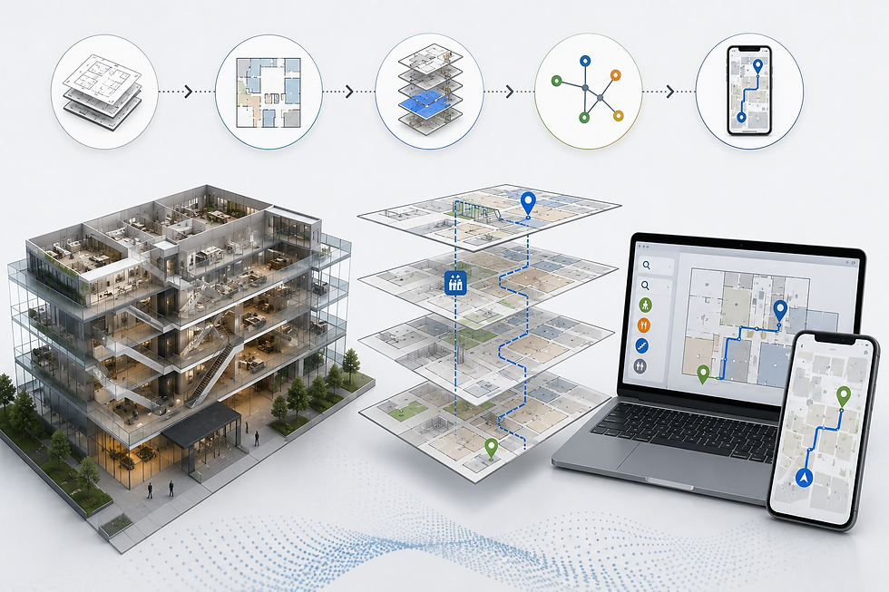
Indoor mapping solutions organize that information into a structured, floor-aware spatial system that people can search, understand, navigate, and use.
Unlike a static floor plan, an indoor map can connect building geometry with meaningful data. A room can be identified by department, function, occupancy status, access level, equipment inventory, or maintenance responsibility. A circulation route can recognize stairs, elevators, secure doors, and accessible paths. A building can also be connected to its surrounding campus, parking areas, roads, utilities, and outdoor infrastructure.
This is why indoor mapping is becoming increasingly relevant to owners, developers, architects, facility managers, operators, healthcare organizations, universities, industrial companies, data center teams, and real estate portfolios.
RENDEREXPO supports this transition through indoor GIS, outdoor GIS, and spatial mapping systems that help convert architectural and site information into organized, GIS-ready spatial environments.

What Are Indoor Mapping Solutions?
Indoor mapping solutions are digital systems that represent the internal spaces of a building in a structured, location-aware format.
They commonly include:
Buildings and individual floor levels
Rooms, suites, departments, and operational zones
Corridors and circulation paths
Entrances, exits, stairs, elevators, and escalators
Amenities and points of interest
Accessible routes
Restricted or secure areas
Equipment and facility assets
Emergency routes and safety information
Connections between the building and its surrounding site
The central difference between a basic floor plan and an indoor mapping system is usability.
A floor plan shows architectural geometry. An indoor map organizes that geometry so it can support navigation, searching, filtering, routing, facility operations, asset visibility, and spatial analysis.
Open indoor spatial standards also distinguish indoor mapping from general building modeling. IndoorGML, for example, focuses specifically on structuring indoor spaces and their relationships for navigation and space-based applications rather than attempting to replace every form of BIM or 3D building data.
Why Static Floor Plans Are No Longer Enough
Architectural drawings remain essential for design, permitting, coordination, and construction. However, a drawing set is not necessarily structured for daily building use.
A PDF floor plan may show every room, but it does not automatically allow a user to:
Search for a department or destination
Calculate a route across several floors
Identify which elevator connects to a specific level
Filter spaces by function or access classification
Locate equipment within a facility
Connect a room to maintenance records
Show an accessible path from parking to a destination
Update occupancy or operational information
Link indoor spaces to outdoor site infrastructure
Indoor mapping solutions address this gap by turning building documentation into an organized spatial information system.
The result is not simply a more attractive drawing. It is a more practical way to understand and use the building.
Core Components of an Effective Indoor Mapping Solution
1. GIS-Ready Building Data
The quality of an indoor map depends on the quality of its source information.
Relevant inputs may include:
BIM models
CAD drawings
IFC files
Architectural floor plans
Reflected ceiling or equipment plans
Site plans
Room and asset schedules
Point-cloud surveys
360-degree imagery
Existing GIS data
Facility management records
Before these sources can support an indoor mapping system, they often require cleanup, alignment, classification, and simplification.
Modern indoor GIS workflows can import information from CAD, BIM, IFC, point clouds, polyline data, and, in some cases, extracted PDF floor-plan features. These workflows also require the source information to be georeferenced and reviewed for data quality.
This preparation stage is frequently underestimated. A detailed BIM model may contain extensive construction information but still require substantial restructuring before it can function as a usable indoor map.
2. Floor-Aware Spatial Structure
A multi-floor building cannot be mapped effectively as a collection of unrelated two-dimensional drawings.
The system must understand:
Which spaces belong to each floor
How floors align vertically
Where stairs and elevators connect
Which entrances serve particular levels
How mezzanines, basements, bridges, and split levels relate
Whether a route can continue between floors
Which areas are public, private, secure, or operational
This floor-aware structure allows users to move through the building logically rather than viewing each level as an isolated image.
3. Meaningful Room and Space Data
Geometry alone has limited operational value. Each mapped space should include useful attributes based on the project’s objectives.
A room might be classified by:
Room number
Space name
Department
Tenant
Operational function
Occupancy type
Access level
Reservation status
Maintenance zone
Asset category
Emergency function
Public or staff use
The correct attributes vary considerably between an office building, hospital, university, manufacturing facility, hotel, or data center.
For this reason, a strong indoor mapping strategy begins with the required use cases, not with a predetermined visual style.
4. Indoor Routing and Wayfinding Logic
An indoor navigation map needs more than corridors drawn on a plan. It requires a connected routing network.
That network may account for:
Doors and passable openings
Hallways and intersections
Elevators and stairs
Restricted access
One-way circulation
Accessible routes
Temporary closures
Public versus staff pathways
Emergency exit paths
Transitions between indoor and outdoor areas
This allows the system to calculate practical routes rather than drawing a straight line between two points.
5. Searchable Destinations and Points of Interest
Users rarely search for geometric information. They search for destinations.
Common searches may include:
A conference room
A medical department
A tenant suite
A classroom or laboratory
A restroom
An elevator
A loading area
A reception desk
A security checkpoint
A specific piece of equipment
An electrical or mechanical room
A useful indoor map must translate technical building information into language that occupants, visitors, contractors, and facility teams can understand.
6. Clear Visual Communication
The visual design of an indoor mapping solution affects how successfully the system can be used.
Maps should clearly distinguish:
Public circulation
Restricted areas
Vertical transportation
Destinations and amenities
Building entrances
Outdoor access points
Assets or operational zones
Current floor level
Route instructions
Too much visual information can make an indoor map difficult to read. Too little information can make it operationally incomplete.
The right balance depends on the user. A public wayfinding interface should be simpler than a facility operations map, emergency planning map, or asset management interface.

Primary Uses of Indoor Mapping Solutions
Indoor Mapping Solutions for Wayfinding and Navigation
Wayfinding is one of the most visible applications of indoor mapping.
Large buildings can be difficult to navigate, particularly when they contain multiple entrances, connected wings, repeated room numbers, secure zones, or several vertical circulation systems.
An interactive indoor map can help users:
Search for a destination
Identify their current floor
Compare route options
Move between floors
Locate entrances and amenities
Follow accessible paths
Navigate from a parking area to an interior destination
Understand connections among several buildings
This is especially valuable in hospitals, airports, universities, convention centers, corporate campuses, shopping environments, government facilities, and mixed-use developments.
Indoor positioning technology can add a live location indicator similar to the blue location marker used in outdoor navigation. However, indoor positioning and indoor mapping are not identical. The map provides the spatial foundation; positioning technology estimates where a device or person is located within that mapped environment.
Facility and Space Management
Facility management depends on understanding how people, places, processes, and building systems relate. Industry guidance defines facility management as supporting the functionality, comfort, safety, sustainability, and efficiency of the built environment.
Indoor mapping can support this work by providing a shared spatial reference for:
Room inventories
Department locations
Space allocation
Workplace planning
Maintenance responsibilities
Operational zones
Cleaning routes
Inspection areas
Vendor access
Capital planning
Space utilization data
Instead of searching through separate drawings and spreadsheets, teams can locate information through the building itself.
This does not mean every indoor map must become a complex facility management platform. In many cases, the first objective is simply to establish reliable, structured spatial data that other operational systems can reference.
Indoor Asset Mapping
Facilities contain thousands of assets that are difficult to manage when their records are disconnected from their locations.
Indoor asset mapping may identify:
Mechanical equipment
Electrical panels
Fire protection components
Medical equipment
Information technology assets
Security devices
Furniture and workplace resources
Industrial equipment
Data center infrastructure
Inspection points
Shutoff valves
Emergency equipment
Location is only one part of asset management, but it is a critical one. A maintenance record becomes more useful when a technician can see exactly where the asset is located, which floor it is on, how to reach it, and what surrounding spaces may be affected.
Emergency Planning and Situational Awareness
Accurate indoor maps can also support emergency planning, responder orientation, evacuation strategy, and access coordination.
Potential applications include:
Emergency access routes
Exit and evacuation mapping
Fire department access
Hazard and restricted-area identification
Stair and elevator locations
Utility shutoff points
Incident command orientation
Search-and-rescue planning
Temporary route closures
Research into advanced indoor 3D mapping has demonstrated the value of helping responders identify hazards, understand unfamiliar environments, locate potential victims, and plan routes into and out of a building. Indoor environments create particular challenges because satellite-based positioning is often unavailable or unreliable inside structures.
An indoor map does not replace emergency procedures, life-safety design, or responder judgment. It can, however, provide clearer spatial information when properly developed, maintained, and integrated into an appropriate operational workflow.
Healthcare Indoor Mapping
Hospitals and medical campuses are among the strongest candidates for indoor mapping solutions.
Healthcare environments commonly include:
Multiple connected buildings
Repeated department names
Public and staff-only circulation
Emergency entrances
Diagnostic and treatment areas
Vertical transportation zones
Service corridors
Restricted clinical areas
Parking structures
Outdoor drop-off and arrival routes
A patient, visitor, staff member, vendor, and emergency responder may each require a different route through the same facility.
Indoor maps can help clarify these journeys while supporting department visibility, equipment location, facility coordination, and campus-to-building navigation.
Campus and Multi-Building Mapping
A building does not exist independently from its site.
Visitors often begin their journey on a road, at a transit stop, within a parking structure, or at a campus entrance. They may then pass through a security checkpoint, walk across an outdoor area, enter a building, and continue to a destination on another floor.
A connected mapping system can link:
Regional and site access
Campus roads and pedestrian paths
Parking and drop-off areas
Building entrances
Lobbies and security points
Interior circulation
Final rooms, departments, or assets
RENDEREXPO’s connected indoor and outdoor mapping approach is structured around this complete spatial journey rather than treating the building interior and surrounding site as unrelated systems.
This is particularly relevant to universities, healthcare campuses, corporate headquarters, industrial facilities, data center campuses, mixed-use developments, and large real estate portfolios.
Construction-to-Operations Information Continuity
Many building owners invest significantly in BIM and digital construction during design and construction. Yet much of that information becomes difficult to use after project closeout.
Indoor mapping can help establish a more practical bridge from project documentation to operational use.
The transition may involve:
Reviewing record BIM and CAD files
Identifying operationally relevant geometry
Simplifying unnecessary construction detail
Standardizing floor and room information
Associating assets with locations
Aligning the building with site coordinates
Preparing data for GIS use
Establishing update responsibilities
The objective is not to reproduce the entire construction model inside a mapping system. It is to extract and organize the information needed for navigation, spatial understanding, facilities, asset visibility, or future digital-twin workflows.
BIM, CAD, and IFC Conversion for Indoor GIS
One of the most important stages of an indoor mapping project is converting existing design information into GIS-ready data.
Why BIM Cannot Always Be Used Directly
BIM models are typically organized for design development, documentation, coordination, quantities, or construction. They may contain:
Excessive geometric detail
Duplicate or temporary elements
Inconsistent room boundaries
Unverified naming conventions
Multiple design options
Construction phases
Linked consultant models
Elements irrelevant to mapping
An indoor GIS system usually requires a cleaner spatial hierarchy centered on facilities, levels, units, rooms, circulation, openings, zones, and points of interest.
Why CAD Drawings Require Preparation
CAD floor plans may also present challenges:
Unclosed room boundaries
Inconsistent layers
Unnecessary annotations
Misaligned floor levels
Duplicate linework
Missing coordinate information
Outdated room names
Differences between design and existing conditions
CAD cleanup is therefore not merely a graphic exercise. It determines whether the resulting map can support reliable spatial data and routing.
The Role of IFC and Open Data
IFC can help transfer building information between different design and data environments. However, the quality of the output still depends on how the original model was structured and exported.
For a platform-flexible workflow, the project team should define:
Required source formats
Coordinate systems
Room and level conventions
Attribute requirements
Update procedures
Quality-control standards
Intended downstream uses
These decisions reduce dependence on a single software platform and help create more durable spatial information.
Indoor Mapping, Indoor GIS, and Digital Twins: What Is the Difference?
These terms are related but should not be used interchangeably.
Indoor Mapping
Indoor mapping is the creation of a digital representation of interior spaces. It may be static or interactive and can support basic visualization, searching, or wayfinding.
Indoor GIS
Indoor GIS adds structured geospatial data, floor awareness, attributes, spatial relationships, analysis, and connections to broader geographic information.
It can relate interior rooms and assets to:
Buildings
Campuses
Parcels
Roads
Utility systems
Environmental layers
Regional context
Indoor Positioning
Indoor positioning estimates the location of a person, device, or asset inside a building. It may use wireless signals, Bluetooth beacons, inertial sensors, or other technologies.
A positioning system needs an accurate indoor map to make the location meaningful.
Digital Twin
A digital twin generally extends beyond mapping by connecting a digital representation to operational, sensor, performance, asset, or lifecycle information.
Not every indoor mapping system needs to become a full digital twin. However, well-structured indoor spatial data can provide an important foundation for future digital-twin development.
How Indoor Mapping Solutions Are Developed
A professional indoor mapping workflow should be driven by project goals rather than technology alone.
Step 1: Define the Use Cases
The team must first determine what the map needs to support.
Possible priorities include:
Public wayfinding
Employee navigation
Space planning
Asset visibility
Emergency coordination
Campus mapping
Facility operations
Tenant communication
Accessible routing
Digital twin preparation
A single project may support several objectives, but the requirements should be prioritized.
Step 2: Review Existing Information
Available BIM, CAD, IFC, PDF, survey, point-cloud, asset, and facility data should be reviewed for accuracy and completeness.
This assessment identifies:
Missing floor plans
Outdated files
Inconsistent room names
Coordinate problems
Gaps between design and existing conditions
Unreliable asset records
Information that requires field verification
Step 3: Structure the Spatial Data
The source information is then translated into a consistent hierarchy of:
Sites
Facilities
Buildings
Floor levels
Units or rooms
Circulation paths
Entrances
Vertical connections
Zones
Assets
Points of interest
Step 4: Develop the Map and Routing Network
The visual map, searchable destinations, room attributes, and routing logic are created according to the selected use cases.
Step 5: Connect Indoor and Outdoor Information
Where relevant, the interior system is aligned with:
Roads
Walkways
Parking
Drop-off areas
Site entrances
Utilities
Infrastructure
Parcels
Outdoor assets
The RENDEREXPO spatial mapping workflow supports this progression from BIM, CAD, IFC, and floor-plan preparation to indoor GIS, outdoor GIS, and connected spatial environments.
Step 6: Test the System
Testing should involve actual users and realistic tasks.
Questions may include:
Can visitors find a destination quickly?
Are floor transitions clear?
Do routes recognize access restrictions?
Are accessible routes represented accurately?
Do room names match current operations?
Can facility teams locate required assets?
Does the indoor map align with the surrounding site?
Step 7: Establish an Update Strategy
Buildings change. Departments move, rooms are renovated, assets are replaced, and access conditions are revised.
The mapping strategy should identify:
Who owns the data
Who approves changes
How updates are submitted
Which source is authoritative
How often information is reviewed
How temporary conditions are handled
How archived data is maintained
Without governance, even a technically strong map will gradually become unreliable.
What Types of Buildings Benefit Most?
Indoor mapping solutions can support many project types, but they are particularly valuable in complex, high-traffic, multi-floor, operationally intensive, or security-sensitive environments.
Examples include:
Hospitals and medical campuses
Universities and schools
Airports and transportation facilities
Corporate campuses
Government buildings
Hotels and resorts
Shopping and mixed-use developments
Convention and event centers
Museums and cultural facilities
Industrial and manufacturing facilities
Data centers and mission-critical campuses
Research laboratories
Residential portfolios
Warehouses and logistics facilities
The strongest business case usually exists when people regularly struggle to find destinations, spatial information is fragmented, facility assets are difficult to locate, or indoor and outdoor operations must be coordinated.
How to Evaluate Indoor Mapping Providers
An indoor mapping provider should understand more than graphic design or software configuration.
The project may require knowledge of:
Architecture and floor-plan interpretation
BIM and CAD data
GIS structure
Multi-floor routing
Site and campus relationships
Facility operations
Asset information
Accessibility
Construction documentation
Visual communication
Data governance
Key evaluation questions include:
Can the provider work with BIM, CAD, IFC, PDF, and survey information?
Does the provider understand floor-aware data structures?
Can the system connect indoor and outdoor environments?
Is the proposed workflow dependent on one platform?
How will data accuracy be verified?
Can the output support both public and operational uses?
How will future updates be handled?
Does the team understand architectural and construction documentation?
Can the map support future asset or digital-twin workflows?
Is the visual interface appropriate for its intended users?
Common Indoor Mapping Mistakes
Treating the Project as a Graphic Floor-Plan Exercise
A visually attractive map can still fail if its room data, level structure, or routing logic is incorrect.
Starting Without Defined Use Cases
Attempting to map everything often produces unnecessary complexity. The team should first identify who will use the system and what decisions it must support.
Ignoring Existing-Condition Verification
Design drawings may not reflect renovations, tenant changes, or field modifications. Critical information should be verified where accuracy affects operations or safety.
Keeping Indoor and Outdoor Maps Separate
Separating the building from its campus can create gaps in the user journey, particularly between parking, entrances, security, and interior destinations.
Including Too Much BIM Detail
Construction-level geometry can make an operational map unnecessarily heavy and difficult to understand
Failing to Plan for Updates
An indoor map is an information system, not a one-time presentation. It needs clear ownership and maintenance procedures.
FAQ Section
Frequently Asked Questions About Indoor Mapping Solutions
What is an indoor mapping solution?
An indoor mapping solution is a digital system that organizes floor levels, rooms, circulation, destinations, assets, and other building information into a searchable and floor-aware map. It may support wayfinding, facility operations, space planning, asset visibility, emergency coordination, or indoor GIS.
How is an indoor map different from a floor plan?
A floor plan primarily shows architectural geometry. An indoor map adds structured room information, searchable destinations, floor relationships, routing paths, points of interest, and operational data that users can interact with.
Can BIM models be converted into indoor maps?
Yes. BIM models can provide valuable floor, room, door, equipment, and spatial information. However, they usually require cleanup, simplification, georeferencing, classification, and restructuring before they are suitable for indoor GIS or navigation.
What information is needed to create an indoor map?
Typical source information includes CAD drawings, BIM or IFC models, floor-plan PDFs, site plans, room schedules, asset data, point clouds, surveys, and existing GIS information. The exact requirements depend on the intended use and required accuracy.
Do indoor maps work without indoor positioning?
Yes. Indoor maps can support searching, route planning, room identification, facility operations, and asset visibility without showing a user’s live position. Indoor positioning can be added when real-time location awareness is required.
Can indoor mapping connect to outdoor GIS?
Yes. A connected system can link roads, parking, pedestrian paths, site entrances, building lobbies, interior circulation, rooms, assets, utilities, and other spatial information into one continuous environment.
How often should an indoor map be updated?
Indoor maps should be reviewed whenever renovations, department moves, access changes, room renumbering, asset replacement, or operational changes affect the mapped information. Organizations should also establish a recurring quality-control schedule based on how frequently their facilities change.

Conclusion
Building a More Useful Spatial Foundation
Indoor mapping solutions transform building information from a collection of static documents into a structured spatial resource.
When developed correctly, an indoor map can support wayfinding, facility coordination, space management, asset visibility, emergency planning, campus navigation, and future digital-twin applications. Its value comes not only from how the map looks, but from how accurately it represents floors, rooms, routes, assets, site connections, and operational relationships.
The most effective strategy begins with clear use cases, reliable source information, disciplined BIM and CAD preparation, floor-aware GIS structure, and a practical plan for maintaining the data over time.
RENDEREXPO helps owners, architects, developers, facility teams, industrial organizations, data center operators, and project stakeholders convert architectural and site information into clear, usable spatial systems. Explore RENDEREXPO’s indoor GIS, outdoor GIS, and spatial mapping services to plan a mapping workflow that connects the building, site, and wider operational environment.


Comments